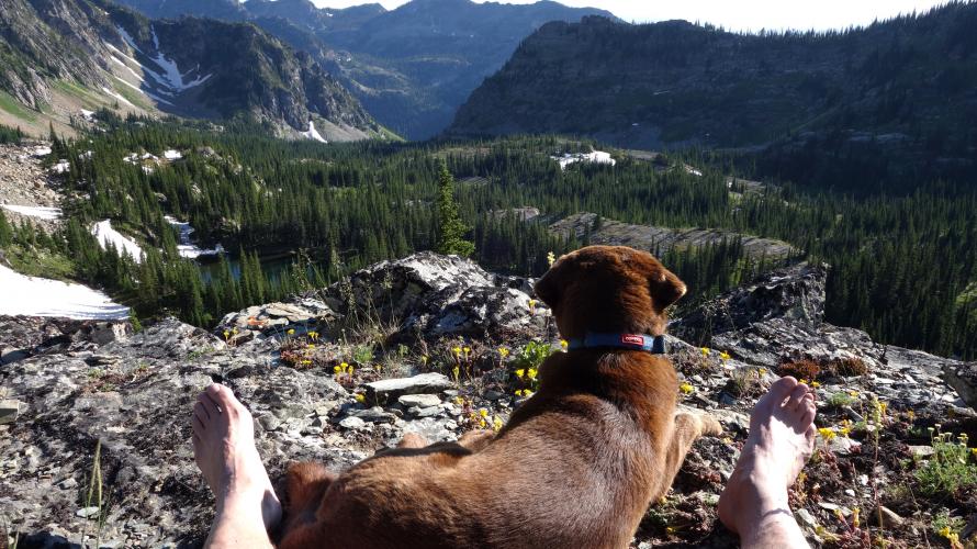
Mission Mountains Wilderness – A Unique Example of Federal-Tribal Cooperation
The Mission Range, or Mission Mountains, are a short, north-south chain of mountains, approximately 50 miles long, and is located in western Montana between the Swan and Flathead Rivers and between Missoula and Kalispell. It is composed largely of a dark sedimentary-type rock known as "Belt Rock". The higher peaks are at the south end, with McDonald Peak as the tallest at 9,820 feet. The range slowly tapers to nothing by Big Fork, where the Swan River turns west to enter Flathead Lake.
The crest of the Mission Range forms the east boundary of the Flathead Reservation, while the east slopes are part of the Flathead National Forest. This range makes up part of the extensive aboriginal lands used by the Salish, Pend d’Oreille and Kootenai Peoples for millenia for hunting, fishing, berries, medicinal plants and spiritual purposes.
Protection of the Mission Range dates back to the 1930s. In 1931 67,000 acres of the east side of the range was designated at the “Mission Mountains Primitive Area”. Over the subsequent years, additional acreage was added to bring that total to 73,207 acres. In 1975 the Mission Mountain Wilderness was established by Congress under the 1964 National Wilderness Preservation System.
On the west side, the Confederated Salish and Kootenai Tribes (CSKT) were as enthusiastic about setting aside these peaks from development. In 1936, the CSKT Tribal Council proposed setting aside this land in the form of a Native National Park – an idea that seemed to have died later in Washington DC. However, the next year, 1937, Chief Forester for the Office of Indian Affairs, Bob Marshall, (yes that Bob Marshall) classified the Reservation side of the Mission Range as a roadless area. This designation stayed in place until 1959, when at the request of the Tribes, this classification was lifted. Facing the threat in the 1970s from the Bureau of Indian Affairs to log the tribal side of the Missions, many tribal members helped spearhead an effort to save the mountains in their pristine condition. Finally, in 1982, Tribal Council passed the Mission Mountains Tribal Wilderness Management Plan, which set aside 91,778 acres of the west side of the Mission Mountains as permanent wilderness. This was the first tribal wilderness to be formally established.
These two areas now constitute just under 165,000 contiguous wilderness acres encompassing forested slopes at the lower elevations, and high mountain valleys, subalpine and alpine lakes, creeks, cascades and waterfalls, rocky cliffs, rugged rocky peaks and some small (receding) glaciers. There is a high level of federal-tribal cooperation in the management of this wilderness gem.
Recreationally, the Missions offer hikers many potential opportunities – some easy, and some more challenging off trail adventures. The east side definitely receives more visitors than the west. There are three main reasons for this: 1) The larger, more fish-filled lakes tend to be on the southeast side. These are obvious target areas for visitors, with lakes such as Gray Wolf, High Park, Crystal and Turquoise Lakes. 2) There are some easy to reach lakes on the east side for day hikes, such as Glacier Lake and Upper and Lower Cold Lakes. In fact, access is so easy to those lakes that camping is prohibited within ¼ mile of the lake shore. Finally, 3) for non-tribal members, a nominal permit is required to enter the tribal side. That alone seems to direct more traffic to the east side.
I live on the Reservation side, so that’s the side I visit the most. Since more people choose the east, when I head out I have excellent opportunities for a real wilderness experience. In fact, if I want absolute solitude, I don’t head to the backcountry in Glacier NP, as awe inspiring as that is. No, I head into the Missions. There are so many places to get away from anyone and everyone there - on both sides to be sure, but particularly on the west side. All one needs is a little off-trail savvy. Once one gets above a certain elevation, the terrain becomes much more open and cross-country travel is not that difficult. That opens up so many more possibilities that just a trail along the valley floor.
One word of caution about the Missions’ 2 main predators. The Tribes maintain a Grizzly Bear Conservation Zone around McDonald Peak. No-one is allowed in this zone from July15 – October 1. There is a healthy grizzly bear population in the Missions so bring bear spray and be smart about odors. And the other predator? Mosquitoes! There’s an even healthier population of those in July and August so bring your DEET! Either way, get out there and enjoy what this corner of Montana has to offer. We live in such a beautiful state, don’t we?
Happy Trails! - Doug Stevens is the Graytrekker
For further information check out these websites:
https://www.wilderness.net/NWPS/wildView?WID=360
