The Mining of Glacier
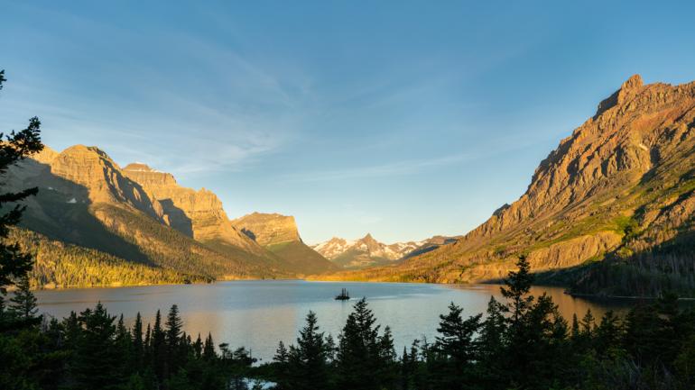
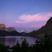
St. Mary at dawn. Photo by Doug Stevens.
There are many superlatives that have been used to describe Glacier National Park, which is why it has earned the moniker, “The Crown Jewel of the National Park System.” Sure, all of our national parks are special places, otherwise they would not have been designated as such in the first place, but even among those already special places, our own Glacier holds an endeared rank. With its glacier-carved peaks and valleys and spectacular lakes, it really does deserve this appellation. However, at the end of the nineteenth century, the lands that now make up our Glacier National Park looked to be headed in a very different direction.
Resource extraction, specifically mining, timber, and to a lesser extent in the nineteenth century, oil, were major drivers in the development of our Western states, Montana included. Left behind in the wake of many of the larger mining operations from that period is an environmental disaster involving tailings, acid mine waste, abandoned shafts and rusting equipment. The romanticism of our “quaint” mining ghost towns are merely the more harmless relics of this period of unbridled lust after shiny metals.
It may surprise many, as it did me, that there are actually abandoned mines and oil wells located within Glacier. The three decades prior to Glacier officially gaining national park status saw a frenzy of mining activity, complete with its own “ghost” town as it became a hub of a mining and oil boom. That’s not quite the image of unspoiled wilderness that is conjured up by the term “national park."
At that time, Montana was still in the grips of “mining fever,” set off by the discovery of gold in Grasshopper Creek (Bannack) in 1862 and reinforced over the following years by successive finds elsewhere. As one mining district played out, miners were eager to find the next big “strike.” The imaginations of these miners, and the rumors that ran rampant through mining camps of new opportunities, only served to feed the visions of “sugar plums” of great wealth that danced in their heads.
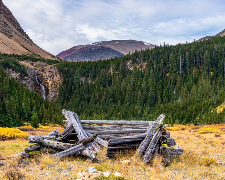
The Van Pelt Cabin. Photo by Doug Stevens.
It seemed like the mountains everywhere in the state held riches lying there for the taking.
It is not surprising, then, that people bought into the rumor that great wealth must lie beneath the uniquely beautiful landscape that is now Glacier National Park.
Enter Elizabeth Collins: an extraordinary, strong, independent woman in early Montana history. She came to Montana from a small farm town in Iowa and initially made her way as a mining camp cook and a nanny; later, she would become a miner herself. She was one of the earliest prospectors in Glacier.
She tried to develop a mine in the Mineral Creek Basin above McDonald Lake in the late 1880s. After three summers working the mine with no apparent success, a professional geologist recommended she abandon her efforts. She went on to find wealth as a cattle baron from her ranch outside of Choteau and earned the nickname “Cattle Queen of Montana.” Officially named “Cattle Queen Creek,” this tributary of Mineral Creek recognizes her early presence in the park. As an aside, there is an old film with this title, starring Barbara Stanwyck and Ronald Reagan, that was actually filmed, in part, outside the St. Mary area of Glacier.
By the beginning of the 1890s the search for wealth under Glacier became more organized.
Finding little evidence of commercially viable ore on the west side of the Continental Divide, rumors began to swirl of rich veins of copper ore on the east side. However, the east side was part of the Blackfeet Reservation and off limits to white prospectors. The mere fact that these lands were inaccessible just served to increase the credibility of these rumors. Eventually, enough pressure was put on the federal government to gain access to these lands that a commission was established to “negotiate” with the tribe to purchase the land from the Continental Divide to the base of the mountains. Finally in 1896, for $1.5 million, the tribe signed away its ownership of what became known as the “Ceded Strip.” Also, in return, the tribe was guaranteed rights to continue to use the land for hunting, food gathering, and other cultural purposes that they had practiced there for millennia. It was opened for mining in 1898, though some “sooners” had already staked claims.
In all, over 2,000 claims were made by approximately 300 people. When the Ceded Strip was incorporated into the new Glacier National Park 12 years later, the tribe lost all the rights that they were originally promised.
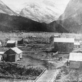
Once the rush was on, the main focus was copper. Some of the prospectors who had sneaked into the east side before it had opened up had found traces of copper ore. Soon, the Swiftcurrent area became the epicenter, and the town of Altyn sprang at the head of Sherbourne Lake on what is known as Cracker Flats. Altyn grew to a population of about 1,000 and featured a post office, a store, several saloons and dance halls (of course), and a two-story hotel. In the end, there were three major mines in the Many Glacier area: the Bull Head Mine on the slopes of Mt. Wilbur by Bullhead Lake, the Van Pelt Mine above Slide Lake and the Cracker Mine on the shores of Cracker Lake directly above Altyn. No commercially viable deposits were ever found, and by 1903-1904 most mining activity was coming to a close.
The Cracker Mine was the largest and most ambitious of the mines. A mine adit (horizontal shaft) about 1,300 feet long had been dug into the mountainside in search of the “mother lode.” During the spring, a 16,000-pound stamp mill had been transported the 29 miles from Ft. Browning to Altyn and up Canyon Creek over the snow by block and tackle to the head of Cracker Lake. However, it was never installed and never turned a wheel.
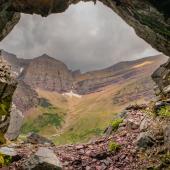
Not one pound of commercial ore was ever produced. The rusting hulk of the stamp mill remains there today—a curiosity for hikers coming from Many Glacier to investigate. [photos of Cracker Mine stamp mill, tailings samples with copper, view from Cracker Mine].
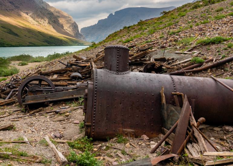
Cracker stamp mill. Photo by Doug Stevens
About the same time as the copper “boom” was going on at Swiftcurrent, oil was observed seeping into the head of Kintla Lake. By 1901 a rough road from Lake McDonald to Kintla was cut, and machinery was being hauled in. Excitement for a big oil boom was in the air. In a 1986 article by Patricia Bick, “Homesteading on the North Fork in Glacier National Park,” a quote from a magazine writer in 1901 summed up the excitement over the Kintla oil field: “Perhaps there is no more beautiful region in the whole Northwest than this virgin wilderness, which the enterprise of man will soon convert into a populous and busy territory with all of the industries of a great oil field in full blast.” What a difference a century makes in the perceived value of unspoiled wilderness!
Drilling carried on for several years at both Kintla Lake and a second well near the confluence of Kintla Creek and the North Fork of the Flathead River (also known as Kintla Lake Oil Well). No oil was ever struck at either, and soon the operation was abandoned. Across the border, near the town of Waterton, oil enthusiasm was also running high and many dry wells had been drilled in the 1890s.
Persistence can sometimes pay off: in 1902 oil was actually struck at a depth of just over 1,000 feet. It was designated “the first oil well in western Canada.” However, over the course of two years, it only produced a total of 8,000 barrels.
By 1904 that well was also abandoned.
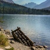
Hikers along the north shore of Kintla Lake nowadays will find the remains of the rusting hulk of a steam concentrator eerily appearing out of the water. [photos of steam concentrator and historic photo of Kintla Lake well].
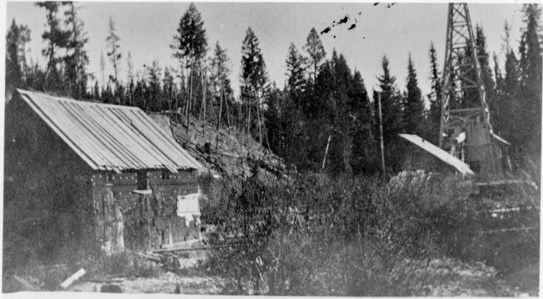
Kintla oil well.
The biggest oil boom in the park was actually back in the Swiftcurrent area again.
Some of the unsuccessful mines had noticed some oil seepage and even bubbles rising up from near the banks of Sherbourne Lake. Again, much excitement was generated, several claims were filed across the Swiftcurrent Valley, and “roughnecks” were brought in to drill. Some small quantities of gas were discovered, but very little oil, if any. Despite this, one well was designated the “first producing oil well in the state of Montana” in 1905. By 1907 the oil boom was over. In all, eight to ten wells were drilled, most within the vicinity of present-day Sherbourne Dam. Of course oil was there, but not really under the mountains. It was probably just traces emanating from the oil fields that lie on the plains at base of the mountains to the east from Alberta to Colorado in what is known as the “Overthrust Belt.” They were looking in the wrong place!
Sherbourne Dam was constructed between 1914 and 1921. The reservoir behind the dam now floods most of the lower mining and oil claims.
Cracker Flats, the site of Altyn, is flooded every year by the impoundment of Swiftcurrent’s runoff.
Even when the Flats are visible at the end of each summer, there is no longer any evidence of the former town. [photo of Altyn and present day Cracker Flats] As the claims were abandoned, the land reverted back to the federal government and added on to the park acreage. The last holdout, the land containing the Cracker and Bulls Head mines, was finally purchased by the Glacier Natural History Association in 1953 for just under $124 and repatriated to the park.
In the end, these mountains dodged a bullet and we are all better off with the undeveloped, pristine wilderness of Glacier National Park. This is the real wealth that these mountains were holding from the very beginning, and it doesn’t take a pick, shovel, dynamite or a drill for all of us to be enriched by it.






- Reply
Permalink